Industrial site monitoring. Technological systems inspection
It is a procedure of supervision and inspection on technological systems of different kinds such as antennas, bridges, wind turbines or civil buildings. It allows, with great precision, to have a complete view of the structural situation, where the human eye struggles to arrive.
Dettagli camera/ottiche Dji M600 Pro
Weight: 10/17 Kg
Max Speed: 65 Km/h
Max Autonomy: 18 minutes
Camera, see specs esa Gopro, Insta 36
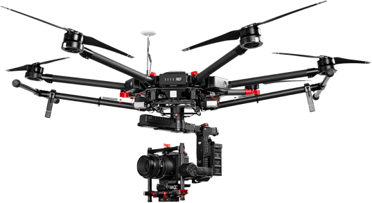
Drone Dji M600 Pro
- Weight: 10/17 Kg
- Max Speed: 65 Km/h
- Max Autonomy: 18 minutes
Solar panel monitoring. Photovoltaic systems
We work on very large plants that need a flight plan to be inspected. Radiometric or multispectral photogrammetries are carried out based on the type of panels (anamorphic or polycrystalline). It is also possible to install two chambers (thermal and multispectral) on the same drone in order to carry out a double analysis at the same time.
Dettagli camera/ottiche Dji Matrice 210 Serie
Weight: 6.14 Kg
Max Speed: 65 Km/h
Max Autonomy: 24 minutes
DJI Z30:
1 / 2.8 ”CMOS sensor
Effective pixels: 2.13M
Lens:
30x Optical Zoom
F1.6 (Wide) – F4.7 (Tele)
Zoom Movement Speed:
– Optical Wide – Optical Tele: 4.6 sec
– Optical Wide – Digital Tele: 6.4 sec
– Digital Wide – Digital Tele : 1.8 sec
Focus Movement Time:
∞ – near: 1.1 sec
6x Digital Zoom
Exp compensation: ± 2.3 (1/3 incremental)
Shutter S 1/30 – 1/6000s
DJI Termic XT:
VIDEO:
FPA 640×512
Analog 720×480(NTSC); 720×576(PAL)
Spectral Band 7.5 – 13.5 μm
Full Freame Exp. 7.5Hz NTSC; 8.3Hz PAL
Scene Range (High Gain)
640 × 512:-13° to 275°F (-25° to 135°C)
336 × 256:-13° to 212°F (-25° to 100°C)
Scene Range (Low Gain)
-40° to 1022°F (-40° to 550°C)
Lens: 13mm f/1.25 45° x 37° 1.308 mr
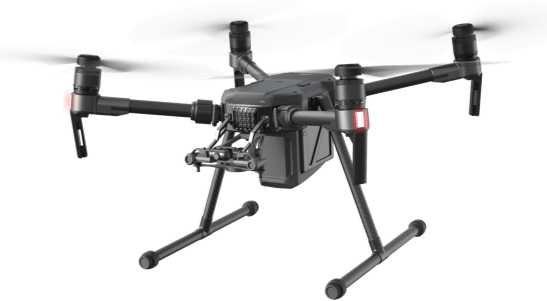
Drone Dji Matrice 210 Serie
- Weight: 6.14 Kg
- Max Speed: 65 Km/h
- Max Autonomy: 24 minutes
Land survey. Photogrammetry and mapping
Aerial photogrammetry, orthophotos and 3D are services designed for architects who, thanks to drones, can easily survey lands and buildings. The mapping service is particularly useful and functional in the field of relief, when it is necessary to search for people by the Fire Brigade.
Dettagli camera/ottiche Dji Matrice 210 Serie
Weight: 6.14 Kg
Max Speed: 65 Km/h
Max Autonomy: 24 minutes
DJI Z30:
1 / 2.8 ”CMOS sensor
Effective pixels: 2.13M
Lens:
30x Optical Zoom
F1.6 (Wide) – F4.7 (Tele)
Zoom Movement Speed:
– Optical Wide – Optical Tele: 4.6 sec
– Optical Wide – Digital Tele: 6.4 sec
– Digital Wide – Digital Tele : 1.8 sec
Focus Movement Time:
∞ – near: 1.1 sec
6x Digital Zoom
Exp compensation: ± 2.3 (1/3 incremental)
Shutter S 1/30 – 1/6000s
DJI Termic XT:
VIDEO:
FPA 640×512
Analog 720×480(NTSC); 720×576(PAL)
Spectral Band 7.5 – 13.5 μm
Full Freame Exp. 7.5Hz NTSC; 8.3Hz PAL
Scene Range (High Gain)
640 × 512:-13° to 275°F (-25° to 135°C)
336 × 256:-13° to 212°F (-25° to 100°C)
Scene Range (Low Gain)
-40° to 1022°F (-40° to 550°C)
Lens: 13mm f/1.25 45° x 37° 1.308 mr
Drone Dji Matrice 210 Serie
- Weight: 6.14 Kg
- Max Speed: 65 Km/h
- Max Autonomy: 24 minutes